
SURVEYING - MICHIGAN - U.S. TOPOGRAPHICAL ENGINEERS - GREAT LAKES
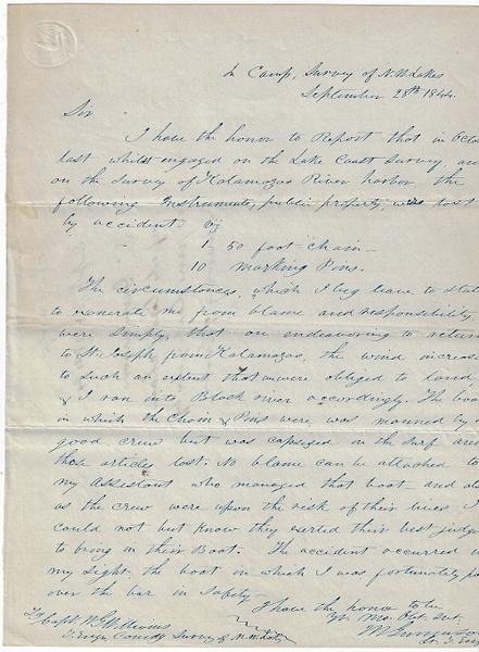
Gunnison, Lt. John Williams. One-page ALS, datelined “In Camp, Survey of N. W. Lakes / September 28th 1844”, addressed to Captain W. G. Williams, Topographical Engineer, Commanding the Survey of N. W. Lakes, written and signed by Lt. J. W. Gunnison, Topographical Engineer, describing the loss of surveying instruments and requesting their replacement. Docketed on the reverse, “In camp / Sept. 28, 1844 / Lt. Gunnison reports loss of chain & pins last year by swamping of boat.” Single page 7.75 x 10 inches.
The request in letter format reads, “I have the honor to Report that in October last while engaged on the Lake Coast Survey, and on the Survey of Kalamazoo River harbor, the following instruments, public property, were lost by accident, viz 1 50 foot chain - 10 marking pins. The circumstances, which I beg leave to state to exonerate me from blame and responsibility were simply that on endeavoring to return to St. Joseph from Kalamazoo, the wind increased to such an extent that we were obliged to land & I ran into Black River accordingly. The boat in which the chain & pins were, was manned by a good crew but was capsized in the surf and those articles lost. No blame can be attached to my assistant who managed that boat and also, as the crew were upon the risk of their lives, I could not but know they exerted their best judgement to bring in their boat. The accident occurred in my sight, the boat in which I was fortunately passed over the bar in safety.”
The U. S. Lake Survey began in 1841 to undertake a hydrographic survey of the Great Lakes region. Captain William G. Williams, of the Topographical Engineers, was appointed in charge of the survey of the northern and northwestern lakes. Williams was later killed in the Mexican War.
One of his surveyors on the N. W. Lakes survey was Lt. James William Gunnison (1812-1853). A New Hampshire native, Gunnison entered West Point and graduated second in his class in 1837. Following service in Florida during the Seminole War and assisting in the transfer of the Cherokee Nation to Indian Territory, Gunnison was transferred to the Corps of Topographical Engineers and assigned first as a surveyor in Georgia before coming to the old Northwest to assist in the Survey of the N. W. Lakes under the command of Capt. Williams. He received his 1st Lt. rank in 1846 and was assigned to accompany Capt. Howard Stansbury’s expedition in 1849-1850 to map and survey the Great Salt Lake region. While in Utah, he wrote a book on the Mormons that was published in 1852 while he was in Washington, D.C. supervising the publication of the Stansbury Expedition report. As a newly commissioned Captain in 1853, Gunnison was chosen to lead a survey for a potential railroad route to the West. While serving in that capacity, Gunnison and several of his survey party members were killed in an ambush in Utah. At the time, it was questioned whether the attackers were Indians or disguised Mormons. The Gunnison name has been memorialized with several Colorado place names.
This letter / document involves two U. S. Army officers who greatly contributed to the better understanding of the Great Lakes region waterways and topography. In addition, Gunnison’s contributions as a topographical engineer in the West helped plot out the development of the Rocky Mountain West and Southwest areas of the United State.