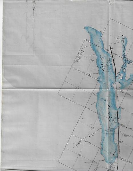

C.M. & P.S. Ry. Co. Map...Missoula County, State of Montana.
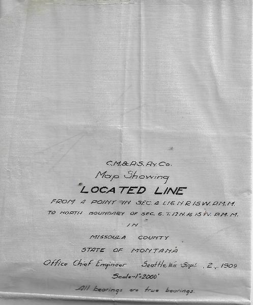
C.M. & P.S. Ry Co. MAP SHOWING LOCATED LINE FROM A POINT IN SEC 4 T.16 N.R. 15 W.P.M.M. TO NORTH BOUNDARY OF SEC. 6. T.17N.R. 15 W. P. M.M. IN MISSOULA COUNTY STATE OF MONTANA . Office Chief Engineer. Seattle, WA. Sept. 2, 1909. All bearings are true bearings. Folded map with immense amounts of mss: 47 x 157 cm. minor wear along the edges, not effecting contents. Accompanied by two land office forms. Being a map printed on approx. eight panels of oilskin. Six panels on the right contain two long manuscript attestations to the surveying accuracy of the provided map. The map occupies four panels and shows a 12 mile route along the Clearwater River from Lake Inez to Seeley Lake. All water areas are colored in blue. Manuscript attestations are signed by both the President and Secretary of the company. Having also two embossed company seals. There are two subsequent amendments. The first is from the Department of the Interior in 1914 and appears to approve the map, with a few manuscript additions. The second is in manuscript from 1923 and appears to cancel the 1914 endorsement due to ‘relinquishment.’ The accompanying land office forms note the changes just stated.