

Claremont Plantation - Surry County, Virginia
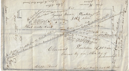
CLAREMONT PLANTATION Claremont plantation is located at the intersection of the Upper Chippokes Creek and the James River in Surry County, Virginia. Built by William Allen Sr. in the mid-eighteenth century, Allen later named it Claremont Manor, presumably after Queen Victoria's birthplace in Surry County, England which was also named Claremont. Claremont Manor dated back to the 1620's when George Harrison, one of the Jamestown settlers, established a small tobacco plantation on the site. He was the victim of the first recorded duel in Virginia in 1623. The plantation passed to the Clement family and then to the Allen family in 1681. The present manor house was built in 1750. According to the map which is being offered, Claremont Plantation was 12,500 "ackers" and became a significant agricultural supplier to the confederacy during the Civil War. The Allen's sold the plantation in 1886 when William Allen, Jr. a lawyer moved to New York City to practice law. In all likelihood this map was drawn during this period as it clearly states that "Clarmont Plantation was owned By Wm. Allen Esq of Richmond." Of interest the plantation was later owned by Millicent Rogers, the granddaughter of Henry Rogers who was the partner of John D, Rockefeller in the Standard Oil Trust. This is the same Millicent Rogers who moved to Taos, NM and became a promoter and champion of Indian rights. The scope of the map spans from Joseph Parker’s property and farm in the south to the James River in the north, and from the properties of William Harrison and John H. Ellis whose name is accompanied by a note reading “colored but smart” in the east to Chippokes Creek in the west. George Brown’s plantation, 316 acres appears to the east of Claremont containing 100 acres of “the nicest timber…I have seen in Virginia”. Cutting diagonally across the map is a route attended by a note reading: “this railroad before the war run back some 10 miles. The iron was taken up for the iron for the Merrimack, the iron clad.” The USS Merrimack was a steam frigate best known as the hull upon which the ironclad warship CSS Virginia was constructed during the Civil War; according to one source, the metal rails from Allen’s railroad were pulled up to make the Virginia’s armor.
Also identified is Point Railroad, shown in the southern portion of the map, near which a note identifies a “great depot for peanuts.” William O. Allen’s slaves are known to have built this miles-long private railway which was used to transport timber from his woodlands to the dock at Scotland Neck on the James River, where his sawmill operation was located. John H. Ellis, evidently a free black man, may have also owned the 50-acre “Ellis Tract” shown east of Claremont Plantation, which features a note reading “half bred, good peepel.” The map identifies numerous features, such as a gate, a cemetery, roads, houses, bodies of water, a “cleared & well fenced” area, creeks, a stone lot, a village called Spring Grove, “small woods,” a smoke house, a steam boat wharf, “heavy timber,” and so forth. Also included are notes concerning the navigation of sloops on Chippokes Creek.
Early in the Civil War, Major William Allen raised a battalion of troops, Company “D” 10th Virginia Battalion of Heavy Artillery, in Surry County, which was stationed at Jamestown. After his troops were ordered to defend Richmond in the spring of 1862, Allen resigned his commission, saying he had already lost $450,000, "that his losses grew daily," and that he was "perhaps the largest loser in the southern Confederacy." During the war Allen supplied timber, hay, and food to the rebel army, which were paid for in Confederate currency. Allen saw his properties ravaged by the war. After the Union navy took control of the James River, Allen's plantations were frequently occupied and looted by the Union Army. Allen's slaves (numbering between 700 and 800) are known to have dug the redoubts that still stand on Jamestown Island. One story alleges Allen ran his steam locomotive off the wharf at Scotland Neck and into the James River to avoid its capture by the Union Army. During the war, Allen moved his family to Richmond, which is where his son William apparently lived at the time this map was created. Allen's trading schooners were sunk or captured by the Union, and his slaves sought and/or attained freedom at Union camps.
The archive includes:
1. A manuscript map of Claremont Plantation and the George Brown Plantation plus added geographic and related historical information. 8 .5 x 14 inches, information designated in both pencil and pen. Very legible and in expected vg cond.
2. Four land deeds from Surry County, Virginia. 28 Sept. 1854; 1 Jan. 1858; 23 Jan. 1858; 11 Dec. 1878. 9 pages total, very legible, but each deed has fold tears and the conditions are only fair.
Three of the four deeds involve John H. Ellis, whose land is featured on this map and who bought land adjacent to William Allen’s property. Ellis bought property as early as 1854 and was married to Rachel W. Ellis. One of the deeds relates to George Brown, whose plantation is featured on this map.